Researchers talk about extreme weather in Greenland
*This article was originally published in ArCS II News Letter No.4 (February 2022).
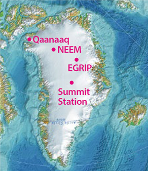 In August 2021, rainfall was observed at Summit Station, the highest point of the Greenland ice sheet (elevation: 3,216 m), making headlines in media reports. In connection with the rainfall event, Arctic researchers who have been observing in Greenland gathered with extreme-event researchers to introduce the causes and effects of recent, frequent extreme-weather events in Greenland and discuss their research findings.
An overview of the 2021 rainfall event at Summit Station
Teruo Aoki (NIPR)
Surface melting in the Greenland ice sheet occurred mainly in the southern part for three days from August 14 to 16, 2021, and rainfall was observed at Summit Station on August 14. Since observation began in 1989, surface-melting events have been observed at Summit Station during the summer seasons of 1995, 2012, 2019, and 2021. The July 2012 melting event was the largest among them, with 97% of the entire Greenland ice sheet surface reported to have melted. During the summer of 2021, three large surface-melting events occurred across the Greenland ice sheet, but the areas were limited to the southern part and smaller in size than the event in July 2012. However, the 2021 events were characterized by a high-temperature phenomenon observed late in the summer, occurring in mid-August. The maximum air temperature of that particular summer season was observed in late summer at some other sites in the southern part as well, whereas the air temperature had already begun to drop in the northern part at that time. Comparing the meteorological elements at the Summit Station in 2012 and 2021, the air temperatures at both times were only slightly above 0°C, and the 2021 rainfall event occurred at +0.5°C or less, a temperature at which it commonly snows in Japan. A possible cause of rainfall is snowflake sizes in the atmosphere being smaller than usual. In mid-August, a high-pressure system over southern Greenland and a low-pressure system over the Canadian Arctic Archipelago facilitated the inflow of warm, humid air into Greenland from the south, resulting in a large positive-temperature anomaly mainly over the southern part of the ice sheet.
Ice core reveals past ice-sheet melting
Kumiko Goto-Azuma (NIPR)
In early July 2012, a year of significant surface melting, we observed rainfall and a rainbow when we were conducting deep ice-core drilling through the NEEM project (The North Greenland Eemian Ice Drilling) in Northwest Greenland. NEEM is a place where ice does not melt even in the summer. At that time, however, the temperature at NEEM was above 0°C, which means it was very warm.
At EGRIP (The East Greenland Ice-core Project), where we are currently conducting ice-core drilling, we found ice layers (portions of frozen rainwater or thawed snow refrozen at snow layers below) in the 2012 layer when digging snow pits. These 2012 ice layers are probably found in many places in Greenland.
An ice core drilled at Summit Station, where the rainfall was observed in 2021, also had an ice layer in 1889. The 1889 ice layer, very famous among researchers, has been found in ice cores drilled in various places in Greenland in the past. The situation in 1889 was likely similar to that in 2012. The concentration of black carbon was also very high in 2012, as it was in 1889. Black carbon possibly has some effect that accelerates ice-sheet melting, such as enhancing absorption of solar radiation.
The impact of atmospheric rivers
What is an atmospheric river?
Naohiko Hirasawa (NIPR)
Simply, an atmospheric river is a “zone of water vapor concentration,” where water vapor accumulates in a vertical direction. The amount of water transported by an atmospheric river can be equivalent to that transported by the Amazon River, which is the reason for the “river” in its name. Research shows that atmospheric rivers transport as much as 90% of their water vapor to high latitudes and polar regions. The number of papers about atmospheric rivers was one or two per year in early 1990s but has rapidly increased, recently topping 400 per year.
Atmospheric rivers and global warming
Naohiko Hirasawa (NIPR)
Global warming will facilitate atmospheric rivers to transport more water vapor into the polar regions. As a result, precipitation in the polar regions will increase. If the precipitation is snow, it will move water evaporated from the ocean onto the ice sheet, which will lower the sea level. At the same time, atmospheric rivers are accompanied by warming events, which cause melting and evaporation of the ice-sheet surface. This mechanism, taking moisture from the ice sheet back into the atmosphere and the ocean, will result in a rise in the sea level. Determining the impact of atmospheric rivers on sea-level change will depend on which of the two effects will be stronger as global warming progresses in the future.
Impact of atmospheric rivers on the rainfall event
Masashi Niwano (Meteorological Research Institute)
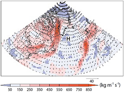
The figure shows the 10-m wind speed and vertically integrated water vapor amount in the atmosphere, both obtained from the latest Japanese reanalysis JRA-55, at the time of the rainfall event on August 14, 2021. A well-developed low-pressure system existed to the west of Greenland, and the winds were blowing northward on the western edge of Greenland. The amount of water vaper is indicated in shaded colors, and the areas colored with light and dark red are considered to be under the influence of an atmospheric river. Therefore, we can say that this event occurred under the influence of an atmospheric river. However, we still do not know whether this kind of pressure pattern is rare or not or why it rained in the high-altitude inland region of the ice sheet. Therefore, the even merits further investigation.
From the perspective of extreme event attribution
Hiroaki Kawase (Meteorological Research Institute)
Extreme event attribution
To quantitively evaluate how human-induced climate change has influenced the possibility and intensity of extreme events.
To determine whether global warming accelerates the surface-ice melting and rainfall frequency in Greenland, the optimal method is to evaluate the last 30 years with numerical simulations of warming and non-warming conditions to obtain the frequency distribution of surface-ice melting and rainfall. On the other hand, if one aims to focus on the rainfall event in August 2021, extreme event attribution is the best approach. This method makes it possible to stochastically verify whether global warming would have increased the possibility of a rainfall event in August 2021 with the frequency distribution and evaluate whether or not the phenomenon was particularly likely to occur in that particular year. Moreover, a quantitative evaluation can simulate the phenomenon at a lower level of global-warming impact, which makes it possible to evaluate whether it would have rained instead of snowed or if the amount of precipitation might have been different in the past. With these three methods for evaluation, we can research the effects of global warming on recent rainfall and surface-ice melting in Greenland.
Changes in the natural environment in Greenland and their impact on society
Shin Sugiyama (Hokkaido University)
In Qaanaaq, a village in northwestern Greenland, the land is mostly covered by glaciers and ice sheet. We currently carry out several researches in this region to understand the impact of glacier and ice-sheet changes on the environment.
One is the impact of calving glaciers on the ocean and marine ecosystem. Because glacier meltwater is much lighter than seawater, it upwells to the surface after discharge into the ocean at a depth of 200 to 300 meters. This upwelling of meltwater enhances glacier melting at the front. We also found the meltwater carries plankton and fish from the deep to the sea surface, which affect feeding environment of birds and marine mammals near the glacier.
Another research subject is glacial floods and landslide, which affect the environment and the lives of local residents. Heavy rainfall and intensive melting on a large ice cap behind Qaanaaq cause flooding that destroys buildings and roads in the village. The impact of flooding and landslides will be even more significant under warming conditions, as steep slopes are destabilized by thawing permafrost.