Research Project (7)
Projection of sea ice distribution and Arctic sea routes
Principal Investigator: Koji Shimada (Tokyo University of Marine Science and Technology)
Sub-Research Project c
Coordinated observational and modeling studies on the basic structure and variability of the Arctic sea ice-ocean system
Principal Investigator: Hiroyasu Hasumi (The University of Tokyo)

Outline
By clarifying the mechanism responsible for the formation of and changes to the structure of the Arctic Ocean, we will build a numerical model that can reproduce this mechanism properly. Through this model, we will gain an understanding of the role of the sea ice-ocean system in the Arctic Ocean amid global climate change.
The oceanic structure of the Arctic Ocean isincredibly complex. The development of any numerical model that is to replicate the state of this body of water has to be very closely linked to actual observations. We are able to gather information about the thickness of the sea ice and the pattern of the ice drift, the process of formation and sinking of denser water through both remote sensing via satellites and from sensing systems moored at sea. In a stepwise fashion we are building high-resolution models, ranging from those that cover various regions within the Arctic Ocean up to models that cover the entire body of water. While working to clarify the mechanism responsible for the formation of the structure of the Arctic Ocean, we are
developing oceanic models that can reproduce the observed conditions to a high degree. The results that we obtain from these models will play a role in the formation of a medium- to long-term sea ice distribution forecasting system that is needed in the use of Arctic Ocean shipping routes.
Through this research, we are contributing to the achievement of strategic research target ④ Projection of sea ice distribution and Arctic sea routes.
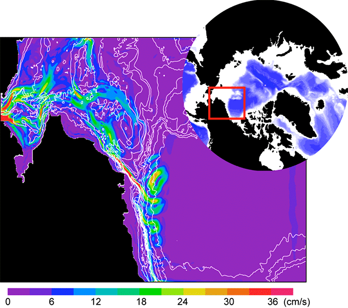
Display of sea surface current speeds in the region near the Bering Strait in the Arctic Ocean simulated by a high-resolution model (the region within the red rectangle in the world map on the upper right-hand side). The white lines indicate the contours of the ocean depths
(Source: Eiji Watanabe, JAMSTEC)