National Institute of Polar Research


[News Release] Optimized Arctic observations for improving weather forecast in the Northern Sea Route
released on November 20, 2015 (in Japanese)
posted on January 13, 2016
National Institute of Polar Research (NIPR)
Japan Agency for Marine-Earth Science and Technology (JAMSTEC)
The Northern Sea Route could be an attractive shipping route during Arctic ice-free periods; however, the decline in sea-ice extent could also cause severe weather phenomena, which could disturb ship navigation in turn. The sparse observational network over the Arctic Ocean makes weather and sea-ice forecasts less accurate and increases uncertainties. However, we show that the quality of weather and sea-ice forecasts can be improved by optimizing the Arctic-observing network.
The current reduction in Arctic sea-ice extent causes unpredictable weather phenomena in the Arctic Ocean (strong winds, high waves, and rapid sea-ice movement associated with cyclones) also over the mid-latitudes (heat waves, severe winters, etc.). With such changing background conditions, more accurate weather forecasts are needed to safely navigate along the Northern Sea Route (NSR) and to understand the climatic linkage between the Arctic and the mid-latitudes. However, this is difficult because of the sparse number of atmospheric observations across the Arctic Ocean. As it is highly difficult to make additional observations in Arctic regions because of limited logistical support, a cost-benefit optimized Arctic observing network is required for improving polar predictions.
In September 2013, Dr. Jun Inoue from the National Institute of Polar Research (NIPR), Japan, and his international research team conducted joint Arctic atmospheric observations using radiosondes (instruments carried into the atmosphere by weather balloons, which measure various atmospheric parameters: Fig.1) on the research vessel Mirai and at meteorological stations surrounding the Arctic Ocean (Ny-Alesund, Alert, and Eureka)(Fig.2). The team launched radiosondes eight times a day from RV Mirai (operated by NIPR and the Japan Agency for Marine-Earth Science and Technology (JAMSTEC)), six times a day from Ny-Alesund (operated by the Alfred Wegener Institute), and four times a day from Alert and Eureka (operated by Environment Canada). Their high daily observing frequency improved the accuracy of atmospheric data used to estimate the state of the climate and weather forecasts because much of the observed data were incorporated into the initial conditions of the weather simulations in real time.
To investigate the impact of these special observations on the weather forecasts over the Arctic, the research team focused on a high-pressure system along the NSR on September 20, 2013 that caused strong coastal winds and rapid wind-driven sea-ice drift over the NSR. They incorporated multiple observations into the initial conditions of the weather simulations, including these special data and conducted ensemble forecasting experiments with an atmospheric general circulation model. The influence of the special observational data on the predictability of the high-pressure system was then tested using the different initial fields by excluding these special data from each station separately. It was found that the uncertainty in the modeled wind fields associated with the high-pressure system was reduced when all the radiosonde data was included. In particular, the data from Ny-Alesund and RV Mirai were very important for predicting this event, partly because of the flow-dependent characteristics in the upper atmosphere. Based on several sets of sensitivity tests, they also determined that four launches per day, once every six hours, is the most cost-effective observing frequency.
Predicted surface wind fields are usually used in sea-ice forecast models as forcing data; therefore, the growth of errors in sea-ice forecasts heavily depends on the accuracy of the predicted wind fields. The research team ran an ice–ocean-coupled model to understand the impact of the accuracy of the predicted wind fields on sea-ice forecasts. It was found that sea-ice forecasts initialized by wind fields that included the special observations adequately predicted the rapid wind-driven sea-ice advection along the NSR.
The research team concluded that additional atmospheric observations would effectively predict not only severe weather phenomena over the Arctic Ocean but also sea-ice distribution influenced by atmospheric forcing. During the Year of Polar Prediction (YOPP), from mid-2017 to mid-2019, proposed by the World Weather Research Programme-Polar Prediction Project (WWRP-PPP), these types of observations and modeling activities will be accelerated within the international framework and could contribute to establishing a sustainable Arctic observing network.
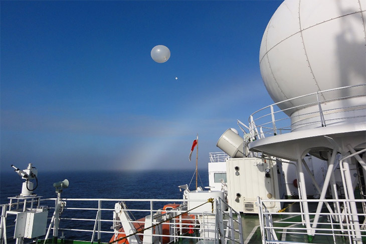
Figure1: Radiosonde observations from RV Mirai over the ice-free Arctic Ocean. Credit: Jun Inoue.
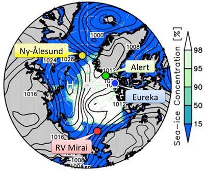
Figure2: Sea level pressure (hPa) and ice concentrations (%) on 21 September, 2013. Special radiosonde observations were made at RV Mirai (red), Ny-Alesund (yellow), Alert (green), and Eureka (blue). Figure adapted from Fig. 1a in Inoue et al., Scientific Reports, 2015
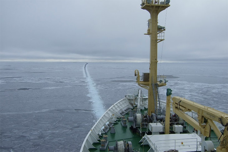
Figure 3: The RV Mirai nosing her way cautiously through a thin ice area. Credit: Jun Inoue.
Published paper
Inoue, J. et al. Additional Arctic observations improve weather and sea-ice forecasts for the Northern Sea Route. Sci. Rep. 5, 16868; doi: 10.1038/srep16868 (2015)
Acknowledgement
This work was supported by a Grant-in-Aid for Scientific Research (KAKENHI(A)24241009) from the
Ministry of Education, Culture, Sports, Science and Technology, Japan, the Green Network of Excellence Program (GRENE Program, Arctic Climate Change Research Project), and the Arctic Challenge for Sustainability Project (ArCS Project).
Contact
Public Relations Section, National Institute of Polar Research
E-mail: kofositu@nipr.ac.jp

Research Organization of Information and Systems / National Institute of Informatics / The Institute of Statistical Mathematics / National Institute of Genetics / Joint Support-Center for Data Science Research
Inter-university Research Institute Corporation Research Organization of Information and Systems
National Institute of Polar Research
10-3, Midori-cho, Tachikawa-shi, Tokyo 190-8518, Japan
Copyright © National Institute of Polar Research All rights reserved.