National Institute of Polar Research


[Research Highlight] Additional Arctic weather data raises forecast accuracy of Japan cold waves
Released on December 21, 2016 (in Japanese)
Posted on March 10, 2017
National Institute of Polar Research
Japan Agency for Marine-Earth Science and Technology
Increased observation of meteorological conditions in the Arctic’s upper atmosphere from land-based weather stations and a sea-going research vessels improve the accuracy of cold wave forecasts for Japan and North America’s East Coast.
A research team consisting of members from Japan’s National Institute of Polar Research, the Japan Agency for Marine-Earth Science and Technology (JAMSTEC), and other organizations conducted forecasting simulations of the cold waves that hit Japan and the North American East Coast in February 2015. Results showed that additional data collected that year through more frequent observation of meteorological conditions in the Arctic’s upper atmosphere from both land-based research stations and the research vessel Lance plying winter Arctic waters improved the accuracy of cold wave forecasts.
In recent years, extreme winter weather events such as heavy snowfalls and severe winters have been occurring frequently in regions such as East Asia, North America and Europe. For example, Japan was experiencing a mild 2014/2015 winter when in February the winter pressure pattern strengthened. With it came record level snowfalls, to the Hokuriku region in particular. Memories are still fresh of the extreme record-setting -15°C cold wave that hit the North American East Coast a week later, which brought with it significant impacts on the region’s people, transportation systems and economy.
To minimize the destructive effects of these extreme winter weather events, accurate forecasting of cold waves flowing in from the Arctic as early as possible is imperative. To that end, it is vastly preferable to have as much meteorological observation data as possible. However, as acquiring such data involves significant personnel and economic cost, its effectiveness needs to be ascertained.
An international research group led by Dr. Kazutoshi Sato and Dr. Jun Inoue of NIPR, and Dr. Akira Yamazaki of JAMSTEC, conducted experimental simulated forecasts of the 2015 cold waves that hit Japan on February 9 and the North American East Coast on February 16.
The collection of larger than usual amounts of Arctic winter weather data in 2015 was due to two reasons: the Norwegian research vessel Lance was in the Arctic Ocean observing and collecting upper atmosphere meteorological data, and the frequency of observation and data collection was increased at some of the land-based observation stations around the Arctic. Using JAMSTEC’s supercomputer, the Earth Simulator, the research team recreated cold wave forecasts for two cases: 1) when there is more frequent observation and more data available than usual (as in 2015) and 2) a “normal” year with less data collection from land-based stations and no additional research resources available.
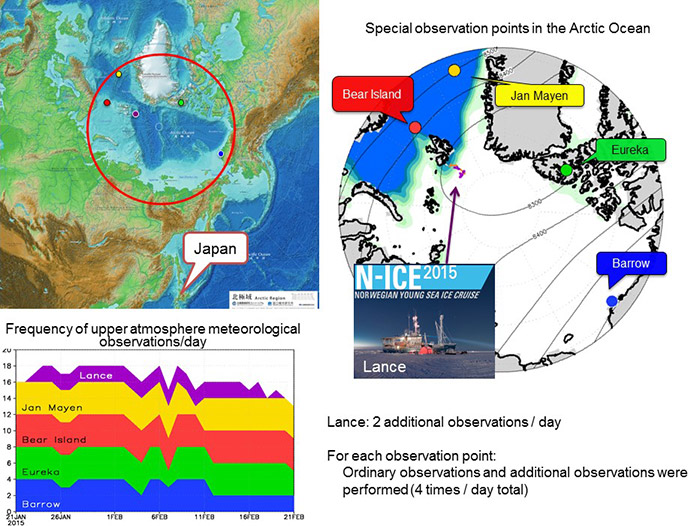
Figure 1: Map of the Arctic (upper left figure) and the observation points where upper atmosphere meteorological observations were conducted (right-hand figure). The data acquired is reported real-time via the Global Telecommunication System (GTS) and used to make weather forecasts. The figure at the bottom left shows a time series of the number of observations that were successfully reported per day. Credit: NIPR/JAMSTEC
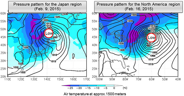
Figure 2: Pressure patterns at the surface (isobars, hPa) and air temperatures at around 1500 meters for the Japan cold wave (Feb. 9, 2015) and North America cold wave (Feb. 16, 2015). There is a west-high, east-low pressure pattern, and low pressure troughs have developed at sea. Credit: NIPR/JAMSTEC
Results of the simulations clearly showed that the additional data collected by the Lance and more frequent collection at land-based stations significantly improved the accuracy of cold wave forecasts.
The additional data collected in 2015 allowed for a significantly more accurate understanding of the dynamics occurring in the center of the cold winter air masses that develop in the upper atmosphere above the Arctic Ocean (the polar vortex), and the initial conditions in the atmosphere from which extreme winter weather events arise. More precise assessment of the initial conditions preceding extreme weather events is indispensable in making accurate forecast calculations.
Associate Professor Inoue of the research team states "This indicates that meteorological observation in the Arctic can help reduce the impact of extreme winter weather events in mid-latitude areas with concentrated populations. It is anticipated that Japan will continue to contribute actively to meteorological observation in the Arctic."
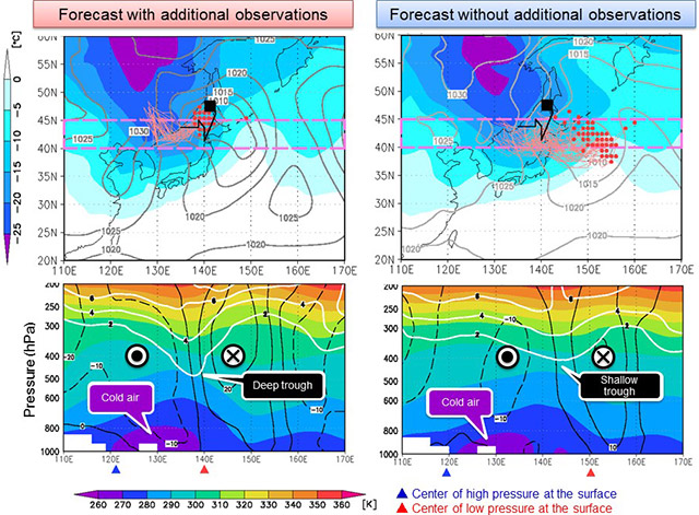
Figure 3: The respective surface pressure and air temperature distributions at around 1500 meters (top); average temperature (potential temperature) inside the dashed areas and the wind speed vertical profile (bottom), for the forecast with additional observations (left) and the “normal” forecast, or forecast without using additional observation data (right). In the figures at the top, the black lines show the actual paths of low pressure; the thin pink lines indicate the paths as forecast through multiple trials (ensemble forecast). The forecast with additional observations matches closely with the black line, but the path and location of the low pressure trough are significantly off in the “normal” forecast, showing high uncertainty (variation in the ensemble forecast is large). Credit: NIPR/JAMSTEC
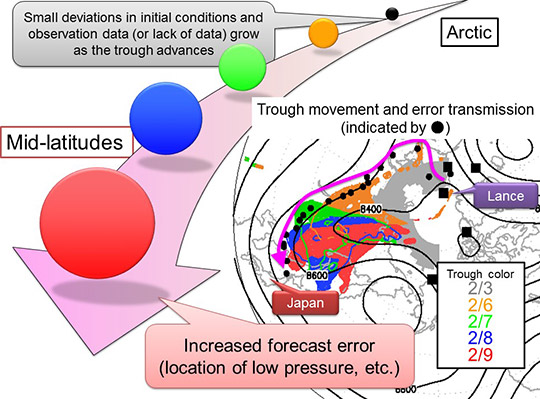
Figure 4: Trajectories of the pressure trough that moves from the Arctic to Japan and of the maximum center of pressure difference (forecast error arising from observations) for forecasts "with additional observations" and "without additional observations" (indicated by ●: every 6 hours). Forecast error arising from the presence or absence of observation data moves from the Arctic to Japan together with the trough. This trough affected the development of low pressure areas around Japan (see Figure 3). Credit: NIPR/JAMSTEC
Published Paper
Journal: Journal of Geophysical Research: Oceans
Title: Improved forecasts of winter weather extremes over midlatitudes with extra Arctic observations
Authors:
Kazutoshi Sato1, Jun Inoue1,2,3, Akira Yamazaki2, Joo-Hong Kim4, Marion Maturilli5, Klaus Dethloff5, Stephen R. Hudson6, and Mats A. Granskog6
1: National Institute of Polar Research, Japan
2: Application Laboratory, Japan Agency for Marine-Earth Science and Technology, Japan
3: SOKENDAI (Graduate University for Advanced Studies), Japan
4: Korea Polar Research Institute, Korea
5: Alfred Wegener Institute, Helmholtz Centre for Polar and Marine Research, Germany
6: Norwegian Polar Institute, Norway
Accepted manuscript online: December 13, 2016
First published: February 1, 2017
DOI: 10.1002/2016JC012197
URL: http://onlinelibrary.wiley.com/doi/10.1002/2016JC012197/full
Funder
Arctic Challenge for Sustainability (ArCS) project
KOPRI research project. Grant Number: (PE16010)
Norwegian Polar Institute's Centre for Ice, Climate and Ecosystems (ICE) through the N-ICE project
Contact
Public Relations Section
E-mail: kofositu@nipr.ac.jp

Research Organization of Information and Systems / National Institute of Informatics / The Institute of Statistical Mathematics / National Institute of Genetics / Joint Support-Center for Data Science Research
Inter-university Research Institute Corporation Research Organization of Information and Systems
National Institute of Polar Research
10-3, Midori-cho, Tachikawa-shi, Tokyo 190-8518, Japan
Copyright © National Institute of Polar Research All rights reserved.