The lowest record of Arctic sea ice extent for October
The extent of sea ice covering the Arctic Ocean changes during the year, reaching its maximum around late February to early March and its minimum around mid-September each year. The sea ice extent is steadily decreasing because of global warming.
The sea ice extent in September 2020 was the second lowest record in the history of satellite observations that began in 1979.
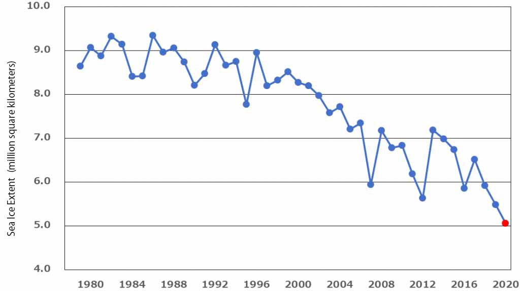
The sea begins to freeze again around the end of September, and the sea ice extent increases rapidly from October to November. According to the Arctic Data Archive System (ADS, Note 2) operated by the National Institute of Polar Research (NIPR), the average sea ice extent in October 2020 was 5.05 million square kilometers, which was the lowest record for October (Figure 1). Almost an area of Japan is missed from the previous minimum of 5.48 million square kilometers in 2019.
Factors that affect the sea ice extent in October include temperature, sea water temperature, wind, ocean currents, cloud cover, summer sea ice extent, and sea ice thickness. Since these conditions change every year, the distribution of sea ice is not the same. Comparing the sea ice extent in October of 2019 and 2020, we can see that there was less sea ice on the Russian side in 2020 (Movie 1). This can be attributed to several factors, including high surface temperatures in northern Russia during the sea ice growth period this year, warmer temperatures in the summer that caused more sea ice to melt, and winds blowing from the Russian coast toward the North Pole in the fall that melted sea ice.
The Eurasian continent is on the left, the North American continent on the right of the screen. The black dot in the center is the North Pole. (movie created by ADS)
How will the sea ice extent change after November? Past observations show that the sea ice extent has been steadily decreasing, but the patterns of the increase and decrease vary from year to year. We also experienced a La Niña in 2020(Note), which could be a factor in abnormal weather conditions around the world.
We plan to interview researchers in the field of sea ice and weather prediction to provide detailed information on the analysis of this phenomenon and future predictions.
In the Arctic Data Archive System (ADS), you can check the sea ice extent calculated based on the data observed by the Earth Observation Satellite “SHIZUKU” of the Japan Aerospace Exploration Agency (JAXA) in semi-real time.
Note
note:La Niña
An ocean-atmosphere phenomenon. During La Niña, the sea surface temperature across the eastern equatorial part of the central Pacific Ocean will be lower than normal. It tends to be extremely hot in summer and extremely cold in winter in Japan.