Permafrost monitoring at post-wildfire sites around Batagay
Reported by Kazuki Yanagiya (Hokkaido University)
Wildfires cause abrupt permafrost thaw, but the fires themselves do not thaw the permafrost. Instead, the fire burns the surface vegetation that acts as a heat insulator, mainly the fluffy moss mats. As a result, it accelerates permafrost thaw until the vegetation recovers. Such permafrost thaw causes ground subsidence and the release of greenhouse gases through microbial decomposition. In recent years, the effects of thawing permafrost have begun to be considered in earth system models to estimate carbon emissions. However, the impact of abrupt thawing due to fires, deforestation, etc., on carbon release is not understood sufficiently because of the variability in the scale and timing of thawing. The latest research concerns that such abrupt thawing can result in carbon release about seven times greater than that of gradual thawing due to rising temperatures.
The world’s largest retrogressive thaw slump, known as the Batagaika megaslump, is located 10 km southeast of Batagay. On the same slope as the slump, two fires occurred in 2018 and 2019. Therefore, our team conducted the first field observation in 2019 and started to analyze the ground deformation at the fire scars using “Interferometric Synthetic Aperture Radar (InSAR).” InSAR is a geodetic method that can detect ground displacement between satellites and the ground surface with an accuracy of a few centimeters. Furthermore, Batagay has a typical continental climate and a dry snowpack so that microwaves can penetrate the snowpack, and it is possible to analyze winter satellite images. In particular, the analysis of high-resolution images revealed that the ground deformation in the fire area was spatially non-uniform. To verify these spatial heterogeneities in deformation, we conducted field observations from September 15 to 20.
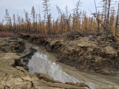
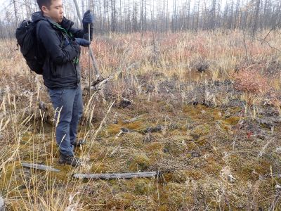
After arriving in Batagay, we headed for the fire site via an unpaved road built as a firebreak. However, over the past two years, part of the road has been eroded down to a depth of 2-3 meters. It makes the road impassable to vehicles. As a result, we witnessed an unexpectedly abrupt deformation (Photo 1). Instead of the vehicle, we reached the fire site by walking through the taiga. Then, we mainly measured the depth to the permafrost layer and the surface soil moisture (Photo 2). The results were generally consistent with the spatial variation of ground deformation.
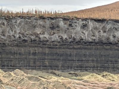
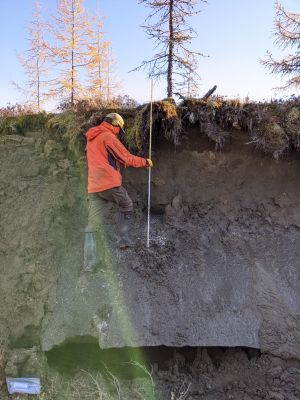
In addition, we confirmed the ice-wedge exposed in the flanks at the Batagaika megaslump and the gully near the fire site (Photos 3 and 4). We are concerned that severe thaw erosion in firebreaks and gullies may trigger the next slump. In the future, we will reveal the process of ground deformation associated with abrupt thaw with satellite data and field observations.
| Observation location | Batagay, Sakha Republic, Northeastern Siberia |
| north latitude | 67.39 |
| east longitude | 134.39 |
| Observation members | Kazuki Yanagiya, Go Iwahana, Nikolai Fedorov, Erel Struchkov |