National Institute of Polar Research


Low-Cost Drone Offers Opportunity to Expand Data Acquisition Coverage in Polar Regions
Scientists use a modified commercially available drone with a radiation shield to obtain high-quality meteorological data
January 7, 2022
Meteorological data collected from polar regions is essential for forecasting climate and weather using operational numerical weather prediction (NWPs) models. One of the instruments in the meteorological observation network, radiosondes provide an atmospheric vertical profile. More radiosondes would improve NWPs but increasing observation cover and frequency needs significant resources. Scientists have successfully gathered high-quality data comparable to radiosonde observations using a modified commercially-available drone, opening doors to improved weather prediction.
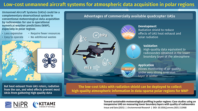
The effects of climate change are being felt most acutely in polar regions. This also makes them the ideal place to study ongoing climate variability. In fact, meteorological data collected from these areas is important for operational numerical weather predictions (NWPs), a technique for predicting the weather based on mathematical modeling. Currently, the daily vertical state of the atmosphere is mainly collected by radiosondes, telemetry instruments for measuring atmospheric parameters, mounted on weather balloons. However, radiosonde networks are limited in polar regions. Moreover, they entail high operating costs in terms of sensors, energy, and human resources. Additionally, radiosondes often leave waste over the land and oceans and could be a source of pollution. It is, therefore, necessary to find a complementary way to strengthen the observing network with high-quality meteorological data for NWPs.
Fortunately, unmanned aircraft systems (UASs) or drones could potentially fit the bill. While UASs are limited to the lower boundary layer of the atmosphere, they have smaller operational costs and are easier to use. However, the quality of data collected by UASs is often reduced by radiation effects (from the sun and the drone body), the deposition of precipitation and cloud droplets, and the position of the sensors relative to wind direction.
In a recent study published in Environmental Research, Dr. Jun Inoue from the National Institute of Polar Research, Japan and Assistant Professor Kazutoshi Sato from Kitami Institute of Technology, Japan, have investigated the possibility of collecting high-quality atmospheric data using a conventional low-cost UAS equipped with a radiation shield. “Sustainable observing networks for NWPs is essential for preparing for weather disasters under the warming climate. Since the number of radiosonde observations have hardly increased in a long time because of the costs of resources, continuous observations with UASs are a highly desirable alternative to achieve sustainable development as well as meet the needs of ordinary people, such as fisherpersons, with improved forecasts,” explains Dr. Inoue. The study was made available online on December 2 2021 and is assigned for publication in Volume 205 of the journal on April 1, 2022.
In their study, the duo focused on a commercially-available drone, the DJI Mavic 2 Enterprise Dual UAS (M2ED). They performed laboratory experiments to determine the horizontal distribution of wind and heat exhaust below the M2ED as a way to gauge the ideal location for the sensors. Then using 3D printing and a heat-reflecting coating, they developed a radiation shield for the sensors that maintained ventilation simultaneously. The shield additionally prevented the deposition of precipitation on the sensor.
Next, they performed field experiments on the M2ED drone and compared its performance with two other meteorologically-customized UASs, the ACSL-PF2- R-SWM and Meteodrone MM-670. This was followed by field tests on the three UASs launched concurrently with radiosondes and a comparison of their performances. The results showed that not only did the M2ED provide high-quality data equivalent to that of the two other drones, its accuracy was, in fact, comparable to radiosondes!
“Our findings demonstrate that it is possible to make the existing polar observational networks sustainable with UASs. This could significantly boost their observation frequencies and spatial coverage through citizen science programs,” says Dr. Inoue.
Those are, indeed, some fine consequences to contemplate!
Original article:
Journal: Environmental Research
Title: Toward sustainable meteorological profiling in polar regions: Case studies using an inexpensive UAS on measuring lower boundary layers with quality of radiosondes
Authors:
Jun Inoue (National Institute of Polar Research, Japan)
Kazutoshi Sato (Kitami Institute of Technology, Japan)
DOI: 10.1016/j.envres.2021.112468
URL: https://doi.org/10.1016/j.envres.2021.112468
Available Online: December 2, 2021
Funding:
This research is supported by the Arctic Challenge for Sustainability II (grant number: JPMXD1420318865), JSPS KAKENHI (grant numbers: JP18H03745 and JP18KK0292), and the Grant for Joint Research Program of the Japan Arctic Research Network Center (grant number: FS02).

Research Organization of Information and Systems / National Institute of Informatics / The Institute of Statistical Mathematics / National Institute of Genetics / Joint Support-Center for Data Science Research
Inter-university Research Institute Corporation Research Organization of Information and Systems
National Institute of Polar Research
10-3, Midori-cho, Tachikawa-shi, Tokyo 190-8518, Japan
Copyright © National Institute of Polar Research All rights reserved.