National Institute of Polar Research


Arctic sea-ice extent reached an annual minimum on 7 September 2025
November 11, 2025
National Institute of Polar Research
Japan Aerospace Exploration Agency
As part of the Arctic Challenge for Sustainability III (ArCS III)(1), the National Institute of Polar Research and the Japan Aerospace Exploration Agency (JAXA) have visualized the temporal and spatial changes in the sea-ice extent in the Northern and Southern Hemispheres based on observation data from the Advanced Microwave Scanning Radiometer 2 (AMSR2) onboard the Global Change Observation Mission – Water “SHIZUKU” (GCOM-W), and have made the data available on the Arctic Data archive System (ADS(2)) website.
On 7 September 2025, the Arctic sea ice reached the yearly minimum extent of 4.58 million square kilometers (Figure 1). This record is the 13th lowest in the 47-year satellite observations since 1979. Looking back at 2025, the Arctic sea-ice extent(3) marked the lowest yearly maximum extent (13.79 million square kilometers)(4) on 20 March in the satellite observations record, and afterward continuously decreased to a lower extent. However, the sea-ice extent slowed its reduction speed in early August and exceeded the 2010s average after late August. A close look at the sea-ice distribution on 7 September 2025 shows that while the sea-ice extent was below the 2010s average from the eastern side of Greenland to the northern part of the Barents and Kara Seas, it was above the 2010s average in the Laptev and East Siberian Seas (Figure 2). In particular, northerly winds caused favorable conditions for sea ice to persist near the coast of the East Siberian Sea(5), contributing to a smaller reduction in the Arctic sea-ice extent. These features in sea-ice distribution, which are different from a normal year, are also seen from in situ observations. On 7 September, when this year’s minimum sea-ice extent was recorded, the R/V Mirai during the Arctic Ocean cruise(6) observed ice-free conditions in the southern Chukchi Sea (left in Figure 3). Later, on 19 September, band-like sea ice was observed in the northern Chukchi Sea during the cruise (right in Figure 3). These contrasting photos show that sea-ice distributions differ by region even within the same month, highlighting the daily sea-ice variability in the Arctic Ocean. Although the 2025 sea-ice extent minimum was 0.51 million square kilometers larger than in 2024, the long-term trend in the Arctic sea-ice extent still shows a sea-ice decline of approximately 84,000 square kilometers (equivalent to the area of Hokkaido) per year (Figure 4). Arctic sea-ice loss significantly impacts marine ecosystems and the climate system. Therefore, monitoring sea-ice conditions and analyzing the underlying mechanisms are essential.
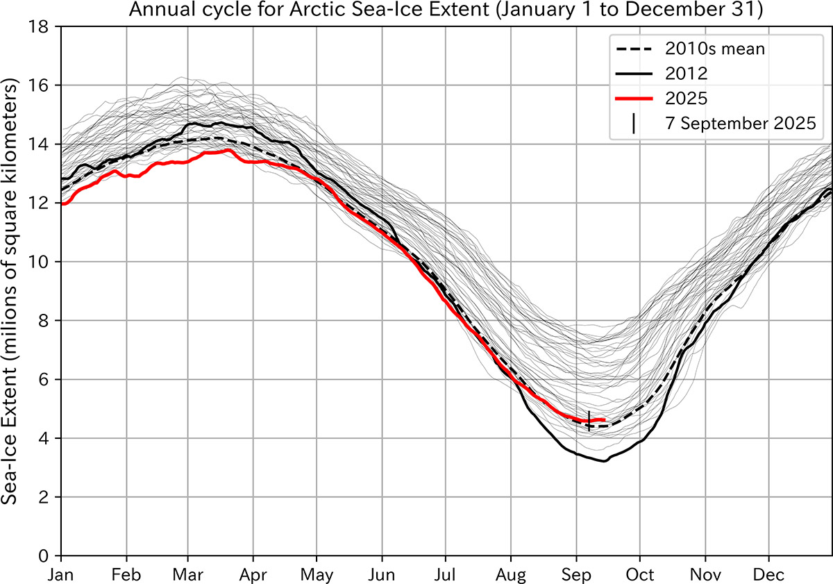
Figure 1: Annual cycle of the Arctic sea-ice extent. The red line shows 2025 (January 1 to September 14), the black line indicates the lowest year in the 47-year record, and the black dashed line represents the 2010s mean (2010-2019).
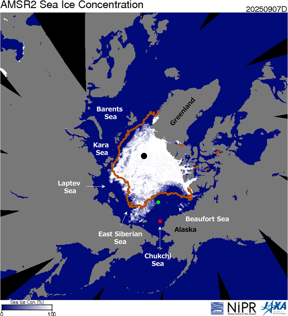
Figure 2: Sea-ice concentration on 7 September 2025. The orange line shows the sea-ice edge (area with at least 15 % sea-ice concentration), averaged over the 2010s (2010-2019) for the same date. Approximate positions of R/V Mirai: 7 September 2025 (red circle) and 19 September 2025 (green circle).
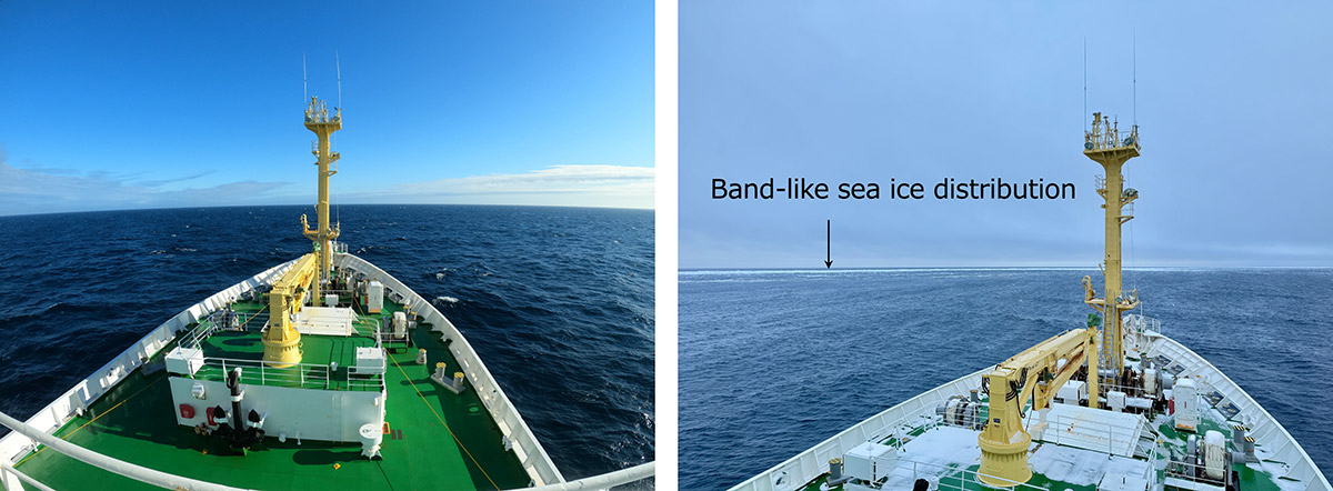
Figure 3. Sea-ice and oceanographic conditions in the Arctic Ocean from R/V Mirai. (Left) Ice-free southern Chukchi Sea shelf (70°50'20"N, 166°28'43"W) on 7 September 2025. (Right) Sea ice in the northern Chukchi Sea (76°23'21"N, 164°27'16"W) on 19 September 2025. (Photos: JAMSTEC/ArCS III).
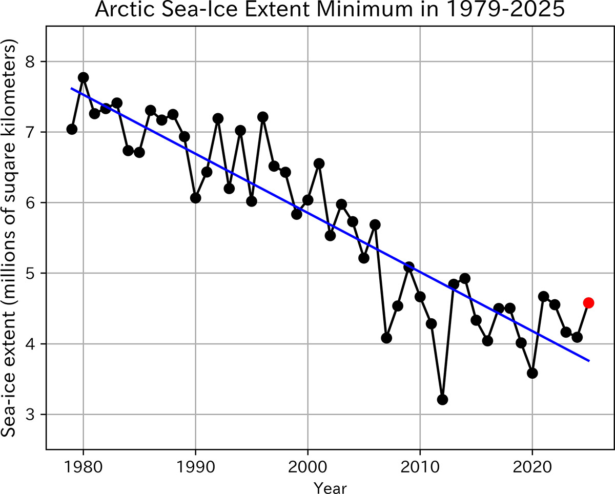
Figure 4. Inter-annual variability in Arctic sea-ice extent minimum (1979-2025, red circle: September 7, 2025, blue line: long-term trend (84,000 km2/year)).
1: Arctic Challenge for Sustainability III (ArCS III, https://www.arcs3.nipr.ac.jp/en/)
National Arctic research projects led by the National Institute of Polar Research. “To create integrated knowledge that contributes to solving the social challenges arising from environmental and societal changes in the Arctic.” Here, “integrated knowledge” refers to combining insights from different academic fields - natural sciences, social sciences, and the humanities - to approach complex challenges from multiple perspectives. The aim is not only to link disciplines, but also to generate knowledge that can inform real-world solutions through collaboration among researchers and with local communities. The implementation period is from April 2025 to March 2030.
2: The Arctic Data archive System (ADS, https://ads.nipr.ac.jp/)
A data archive system for preserving and managing observation data and model simulation products obtained in the Antarctic and Arctic regions through the GRENE Arctic Climate Change Research Project (2011-2016), Arctic Challenge for Sustainability (ArCS, 2015- 2020), Arctic Challenge for Sustainability II (ArCS II, 2020-2025), and Arctic Challenge for Sustainability III (ArCS III, 2025-2030)
3: Sea-ice extent
For details on the calculation method of sea-ice extent, please refer to https://ads.nipr.ac.jp/vishop/#/dataset. In this article, we used a five-day average.
4: Lowest record of winter Arctic sea-ice extent maximum
Please refer to https://www.nipr.ac.jp/info2025/20250418.html (in Japanese)
5: Arctic and Antarctic sea-ice information in August 2025
Please refer to https://asic.nipr.ac.jp/info/2025-09-11-01/ (in Japanese)
6: Mirai Cruise 2025 (In Japanese)
Please see https://www.arcs3.nipr.ac.jp/en/report/2632/

Research Organization of Information and Systems / National Institute of Informatics / The Institute of Statistical Mathematics / National Institute of Genetics / Joint Support-Center for Data Science Research
Inter-university Research Institute Corporation Research Organization of Information and Systems
National Institute of Polar Research
10-3, Midori-cho, Tachikawa-shi, Tokyo 190-8518, Japan
Copyright © National Institute of Polar Research All rights reserved.