Arctic Data archive System (ADS) has been publishing a variety of data acquired by the Earth observation satellite "SHIZUKU" (AMSR2) of JAXA.
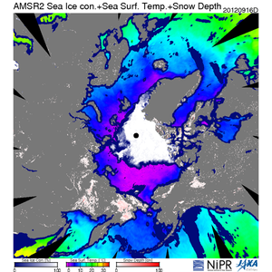
Out of the data, the sea ice concentration and sea surface temperature of the Arctic Ocean data gets the most attention. ADS has been accessed not just from the Arctic researchers but also from people all over the world. Arctic sea ice extent generally records the least in mid-September each year. In recent years, a lot of people pay attention on how much the Arctic sea ice extent will be reduced in summer because the minimum sea ice extent in satellite observation history was recorded in 16th September, 2012. This increases the number of accesses to ADS from August to September. Watching daily changes of the sea ice by the animation is also available on ADS. With the undulate animation in your mind, a new discovery might be born. Personally, it is fun to predict when sea ice area will be the minimum every year by using ADS’s real-time sea ice area data of the Arctic Ocean. Such information is becoming more important for the Arctic sea route in recent years.
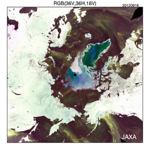
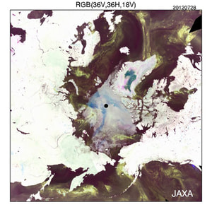
Although it doesn’t get much attention, color composite images (RGB (36V, 36H, 18V)) of the microwave are also published on ADS. You can monitor the cloud flow over the Arctic Ocean, the temperature conditions of the land area of the Arctic region, and the summer melting status of Greenland surface with these images. It was observed that the whole area of Greenland was melt on 12th July, 2012. We wish that we could have provided the image of the day, but unfortunately there was no data on ADS because Japanese microwave sensors had been switched during that period.
With that said, satellite observation is a very important tool for the Arctic observations. However, I have heard that the plan of launching successor of the Earth Observation satellite reaches a deadlock in Japan. Japan has lead the world’s research community of the Arctic region by operating two microwave sensors, AMSR-E (since 2002) and AMSR2 (since 2012), which are able to observe the Arctic region. However, it seems that there is no plan on launching AMSR2 successor machine. I hope this important satellite would continue to be operated.
Hironori Yabuki, NIPR
(Principal Investigator of the "Arctic Data Archive System" research program)

Composite image of sea ice concentration, sea surface temperature and snow depth in September 16, 2012 (Sea ice extent minimum recode in historical satellite observation)
 Color composite image (RGB (36V, 36H, 18V)) of the microwave in September 16, 2012.
 Color composite image (RGB (36V, 36H, 18V)) of the microwave in July 28, 2012. White part was melted area at the surface of Greenland.


