The main part of our glaciological field work was targeting an area near the calving front of Bowdoin Glacier, 20 km away from Qaanaaq village. This is the most dynamic, fast changing, and, undoubtedly, the most spectacular part of the glacier to see and work at. It has been studied since 2013, and a continuation of observations is important for understanding the behavior and future of this glacier under climate change. Before Japanese researchers, this site was briefly visited only by an expedition of an American explorer, Robert Peary, 120 years ago. These days only local people occasionally visit Bowdoin fjord for narwhal hunting.
On July 4, immediately after our arrival with a helicopter, our work has started at several locations at and around the glacier. As soon as we completed helicopter-transportation of 11 people and at least 3 tons of materials to camp sites and key observation spots, we established our base camps near the glacier. It was the core of all our research operations and daily life.
After this, the first few days were dedicated to the most important task: to install stand-alone sensors, instruments and markers for measurements, and, indeed, to make sure that they perform properly. Namely, our teams installed:
- 1 Automatic Weather Station;
- 6 GPS stations to monitor ice speed;
- several stakes for monitoring ablation (or melt of ice);
- two on-ice seismic arrays for studying icequakes (5 surface and 3 borehole stations);
- an infrasound array with 8 elements, and a water-pressure sensor for documenting calving and tsunamis caused by calving;
- a radar for high-frequency ice surface mapping;
- several time-lapse cameras;
- Finally, at least 10 reference points for geo-tagging aerial photography made with drones.
Following this busy phase with 12-hours working days, we gradually entered a more 'relaxed' maintenance phase with 8-hours working days, requiring us to visit some of our sites on a daily basis and to take care about our instruments or prepare them for winter operation. At the same time, some of us were collecting data from over-winter-installations, as well as water and rock samples for biological and geochemical analysis. Simultaneously, Swiss team was flying their fleet of Unmanned Aerial Vehicles, UAVs (or drones) over our heads for constructing high-resolution maps of the ice surface.
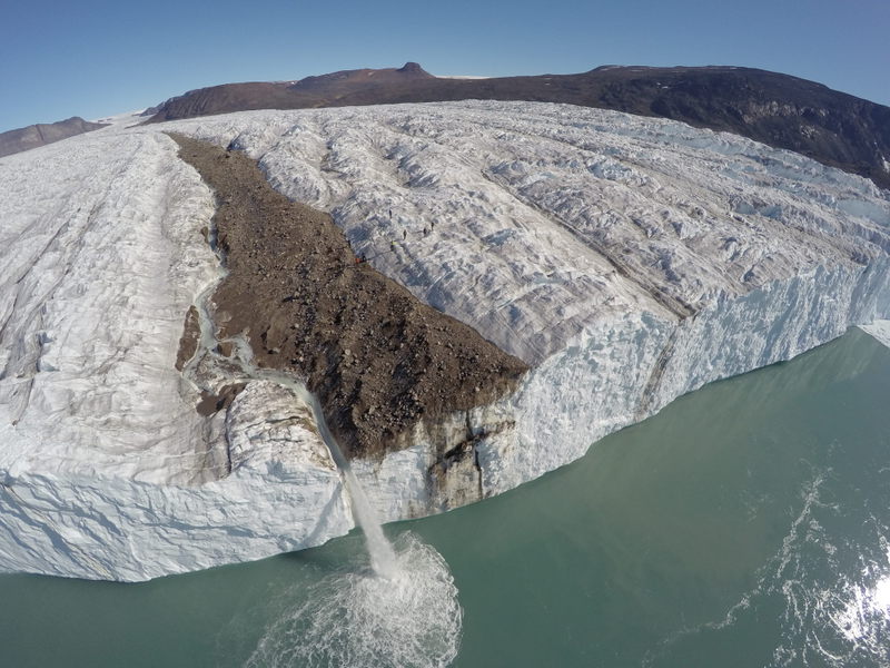
From above, Bowdoin Glacier reminds an ocean of frozen storm waves, with a peak-to-peak amplitude of 5 to 10 meters. This triangular pyramid-looking ice 'waves' are cracked by many water-filled crevasses due to strain in the ice, darkened with dust and sediments, and eroded by water streams. Approximately in the center of the glacier there is a band of rocks and sediments, stretching from the calving front far inland and called the 'central morene'. For us it serves as a convenient highway to walk along the glacier. It allows our feet to rest a little bit from ice-crampons. Also, here we have 2 depots, there we leave or take some materials, and make appointments with colleagues. Boulders and rocks of this morene are quite diverse, one can find all kinds of granite, quartz and other rocks with inclusions of shiny red garnet.
As we arrived to Bowdoin, the glacier fjord was still covered with a so-called ice mélange (a mix of icebergs, sea-ice and ice chunks). The fjord was completely clear of ice on a day of our departure, and visited by birds and seals, as we could see from the ice cliff.
Most of our equipment is running on batteries charged with a solar power, which is available to us 24 hours per day at this high latitude of 78 degrees during a long polar day. In general, the weather was very comfortable during 3 weeks of our work. It was sunny, sometimes even warm enough for a T-shirt, especially in our tents. Almost no wind, episodic clouds. This good weather was a real luck for a success of our observations and for our safe evacuation back to Qaanaaq on July 21 for continuing oceanographic phase of the program.
Evgeny Podolskiy (Hokkaido University / A member of Theme 2)
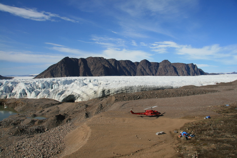 Arrival to the base camp site by Air Greenland helicopter charter
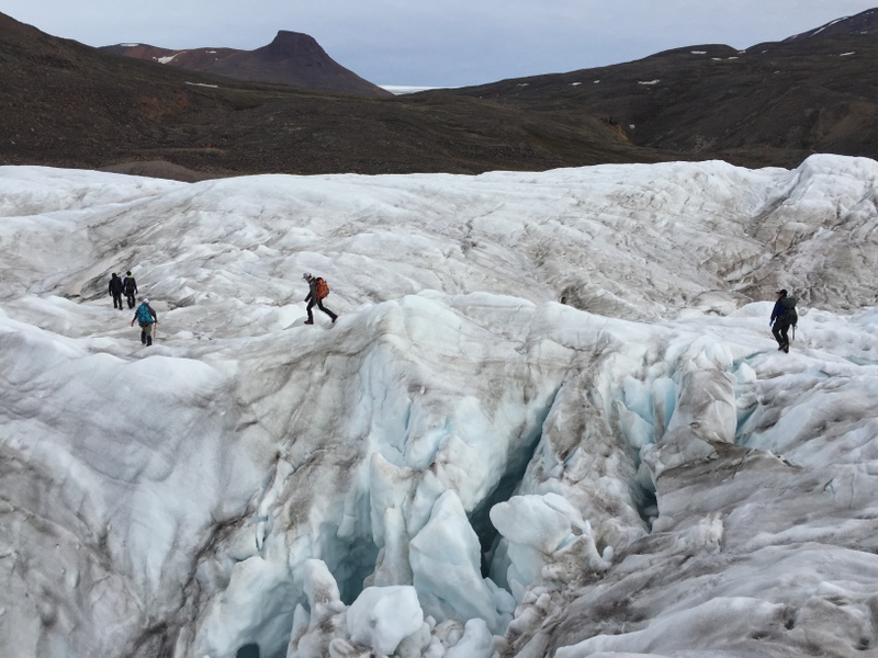 Daily crossing of Bowdoin Glacier
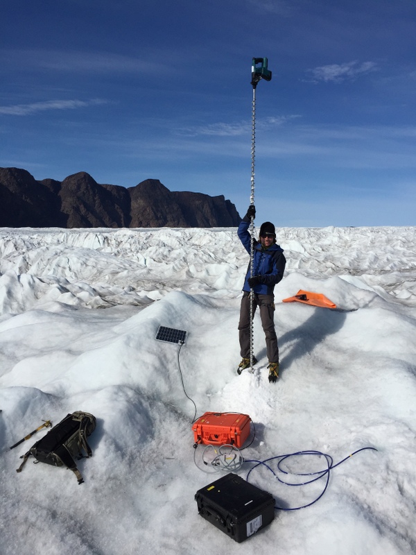 Drilling 4 m into ice for borehole sensor installation
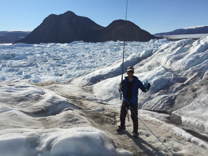 Collection of water samples from a plume directly from the ice cliff
 UAV-photograph of all participants at the calving front (the photograph is a courtesy of Guillaume Jouvet, ETH Zurich)
Other posts of Qaanaaq observation
<2016>
- Field observation in Qaanaaq, northwestern Greenland (From Qaanaaq 1)
- Oceanographic observation in the Bowdoin fjord near Qaanaaq, northwestern Greenland (From Qaanaaq 3)
- Workshop with Qaanaaq village people (from Qaanaaq 4)
<2017>
- Research expedition on the northwestern Greenland Ice Sheet 1 - Maintenance of Auto Weather Station -
- Research expedition on the northwestern Greenland Ice Sheet 2 - Geophysical survey at Bowdoin Glacier, northwest Greenland (6-17 July 2017) -
- Workshop with Qaanaaq village people
- Ocean observations in Bowdoin Fjord, Northwest Greenland
<2018>
- Ice cap and outlet stream observations in Qaanaaq, northwestern Greenland
- Workshop with the residents of Qaanaaq in Greenland
- Ocean measurements in Inglefield Fjord and workshop with the residents of Qeqertat Village in Greenland
<2019>
- Field observations of surface mass balance and meltwater discharge on Qaanaaq Ice Cap, northwestern Greenland
- Field observation in Bowdoin Glacier, northwestern Greenland
- Oceanographic observation in Inglefield Fjord and workshop with residents in Qeqertat Village, northwestern Greenland