The main program of an international expedition to Bowdoin Glacier on Greenland's northwest coast was successfully completed last week. This 3-km-wide calving glacier has been an important study site of Japanese researchers and their foreign colleagues during the last 5 years.
Bowdoin flows from the main Greenland Ice Sheet into the sea between legendary military locations of Cold War, called “Thule” and “Camp Century”. Recently this region has been experiencing dramatic ice loss, and Bowdoin Glacier has been also rapidly thinning.
The scientific work of 2017 at Bowdoin was led by Shin Sugiyama (Hokkaido University, Japan) and Martin Funk (ETH Zurich, Switzerland) from 2 different base camps:
Five participants from Hokkaido University (Shin Sugiyama, Evgeny Podolskiy, Daiki Sakakibara, Naoya Kanna, and Shingo Fukumoto) and one researcher from ETH Zurich (Lukas Preiswerk) stayed in the base camp at the eastern margin of the glacier. This part of the team worked mainly at the ice surface near the calving front.
Three participants from ETH Zurich (Martin Funk, Andrea Walter, and Marin Kneib) were living in the second camp (called “Hill”) on the top of 480-m-high Sentinel Nunatak, facing the calving front. Our colleagues were staying at such altitude in order to conduct remote ice speed observations with a radar and regular drone (UAV) flights.
Additionally, some major logistical efforts of the campaign were combined with the third parallel project ''Sun2Ice'' led by Guillaume Jouvet (ETH Zurich). This project was run from Qaanaaq and Qeqertat and focused on detailed aerial survey of glaciers at a fjord, Inglefield Bredning, with several long-range drones, including “Atlantic Solar” sun-powered unmanned aircraft.
Joint, mutually beneficial operations of these three camps resulted in a well-coordinated and well-integrated team work. Aerial survey, backed by ground-validated observations, allowed to direct and update on-ice-team about the conditions near the calving front. Such near-real time feedback was crucial for safe and efficient observations. It allowed to obtain unique measurements from one of the most difficult-to-access areas of the glacier, where icebergs are detached and collapse into the fjord.
Overall duration of the expedition had to be shortened due to an unfortunate week-long delay of our flights by ''Air Greenland''. The delay left us only one night for logistical preparations of a couple of tons of expedition supplies at the village of Qaanaaq before the departure of a charter helicopter to Bowdoin Glacier. Nevertheless, nearly 2 weeks of our campaign were densely packed with remarkable events and left our scientific and emotional expectations totally satisfied.
Immediately after our landing on the glacier surface, at approximately 200 m from the calving front, we noticed a large-scale transverse crevasse (or a rift). The very next night (July 8, after midnight), a block of ice about 50x500x100 m3 calved off. It was accompanied with an impressive thunder-like noise and a cloud of ice dust and water splash tens of meters above the ice, which were produced by iceberg capsizing replacing enormous amounts of water and breaking up the ice melange by tsunami. Later on, the newly formed calving front provided an opportunity to deploy oceanographic instruments directly from the ice cliff into the expected location of a subglacial-water plume, which attracts sea gulls and seals.
The following several days were filled with intense activities dedicated to geodesic survey across the glacier, water sample collection, CO2-emission measurements, deployment and maintenance of various instruments (e.g., 5 GPS stations, 9 seismometers, Automatic Weather Station, a few time-lapse cameras, a few sensors logging water pressure, salinity, temperature, and etc.). Moreover, we worked on one of the key aims of our campaign to retrieve heavy installations of several long-term borehole experiments.
After that, on July 13, the glacier impressed us for the second time:
Next to our base camp, a lake formed due to river damming by the lateral margin of the glacier. In the evening, a large momentum wave (i.e., a tsunami or a seiche) was produced by a collapse of an ice serac into the lake. The water pressure sensor was washed away from the coast and could not be found until the next, the third impressive event happened...
This time, it was a Glacial Lake Outburst Flood (GLOF):
On July 14, the lake completely drained several hundred thousands m3 of its water into a subglacial channel just in a few hours.
This outburst exposed a large 30-m-deep cavity or a chasm, which looked like eroded limestone amphitheater.
As GLOF was happening, we also received a radio-call from our Swiss colleague based at the “Hill” camp, who said that the long-awaited plume had finally appeared on fjord surface exactly below recently deployed sensors. Meaning that our last-year assumption about hydraulic connectivity between one of the plumes and the lake has been proved!
All these rare and spectacular events were recorded by different instruments and will certainly provide important insights into glacier and fjord dynamics. Considering all other observations, including successful retrieval of long-term winter data from borehole installations, we are anticipating interesting findings about the complex ice-ocean interactions.
Evgeny Podolskiy / Shungo Fukumoto (Hokkaido University)
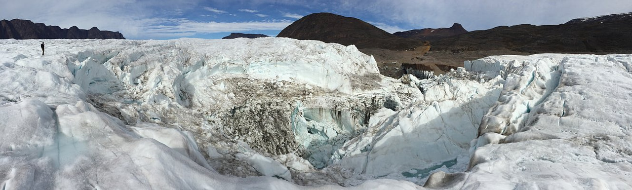
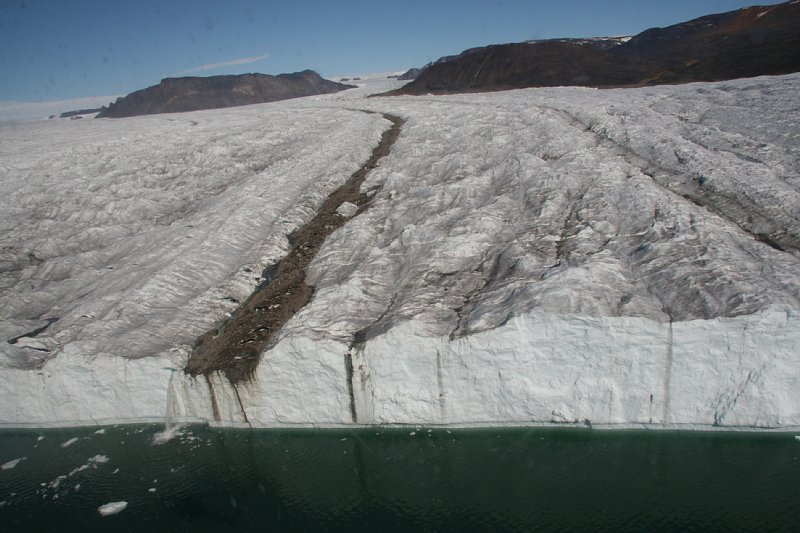 The end of Bowdoin Glacier, calving front
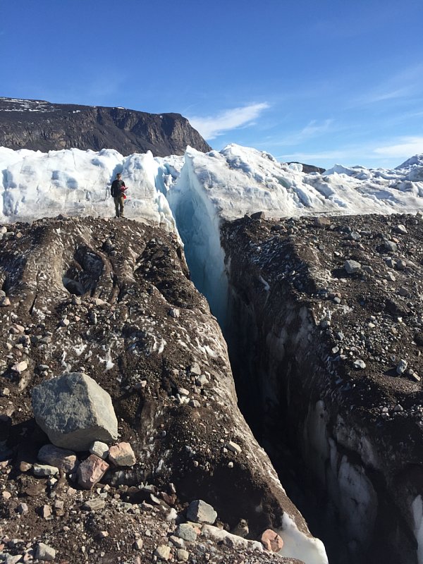 Large-scale transverse crevasse
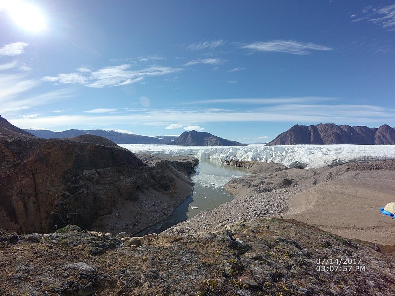 The lake before the drainage
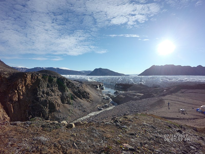 The lake after the drainage
 This outburst exposed a large 30-m-deep cavity or a chasm, which looked like eroded limestone amphitheater.
Other posts of Qaanaaq observation
<2016>
- Field observation in Qaanaaq, northwestern Greenland (From Qaanaaq 1)
- Field campaign in Bowdoin Glacier, Greenland (From Qaanaaq 2)
- Oceanographic observation in the Bowdoin fjord near Qaanaaq, northwestern Greenland (From Qaanaaq 3)
- Workshop with Qaanaaq village people (from Qaanaaq 4)
<2017>
- Research expedition on the northwestern Greenland Ice Sheet 1 - Maintenance of Auto Weather Station -
- Workshop with Qaanaaq village people
- Ocean observations in Bowdoin Fjord, Northwest Greenland
<2018>
- Ice cap and outlet stream observations in Qaanaaq, northwestern Greenland
- Workshop with the residents of Qaanaaq in Greenland
- Ocean measurements in Inglefield Fjord and workshop with the residents of Qeqertat Village in Greenland
<2019>
- Field observations of surface mass balance and meltwater discharge on Qaanaaq Ice Cap, northwestern Greenland
- Field observation in Bowdoin Glacier, northwestern Greenland
- Oceanographic observation in Inglefield Fjord and workshop with residents in Qeqertat Village, northwestern Greenland